

Jeff Houghton
Exploring the Underwater Realm
“Just because we live in different jurisdictions doesn’t mean the water cares. It will flow where it flows. And if we’re going to have a sustainable and informed approach to solve some of these problems, it requires that holistic view.”
Meet Jeff. As a boy he fished with his father and scuba-dived with his twin brother in the lakes of northern Wisconsin. Jeff became scuba-certified at age 13 and always wanted to find a career that would involve exploring underwater—inspired by Discovery Channel videos that revealed an amazing universe of life below the waves. At the UW-Milwaukee School of Freshwater Sciences as a research specialist in the lab of Dr. John Janssen, Jeff has found a role that enables him to use his passion and ingenuity to explore beneath the waters of our Great Lakes. Supported by a grant from the Fund for Lake Michigan, Jeff is surveying four Lake Michigan harbor areas to produce both data-intensive and public-facing maps highlighting fish habitat hotspots. This research is revealing fish in forgotten backwaters and setting the stage for efforts to improve habitats in ways that also support our coastal communities. Jeff hopes to map four more harbors in the future—and is even more excited about combining his natural sciences acumen and computer skills to create visually compelling designs for underwater features that can not only improve fish habitat and but also effectively communicate what’s important to us landlubbers.
A harbor map illustrated by Kim Beckmann; click to learn more about the Milwaukee Estuary harbor habitat hotspot maps.
What does a research specialist do? A little bit of everything. “Really, growing up I always hoped to be a marine biologist,” Jeff muses with a laugh. “Right? That’s probably on the list: ‘I want to be a firefighter, an astronaut, and then a marine biologist.’… How do you be a marine biologist in the Midwest? The Great Lakes are as close as you’re going to get.” Jeff has learned how to use complex computer programs, interpret data from side-scan sonar or fish gut contents, operate ROVs (remotely operated vehicles), and, of course, perform scientific dives in the Great Lakes.
Jeff holds an undergraduate degree from UW-Stevens Point in natural resources, wildlife management (and double-majored in biology for good measure). His twin brother Chris, who shares his brother’s passion for natural resources and skill for scuba diving, found a position in Dr. John Janssen’s lab before the School of Freshwater Sciences was established, when the researchers and labs here were part of the Great Lakes WATER Institute. After working outside his field for a few years, Jeff followed Chris to Milwaukee and joined Dr. Janssen’s lab on a five-year project detailing the colonization of an artificial reef off the coast of Oak Creek, Wis. This research led Jeff to obtain his master’s degree from the School of Freshwater Sciences as part of the school’s first cohort of graduates.
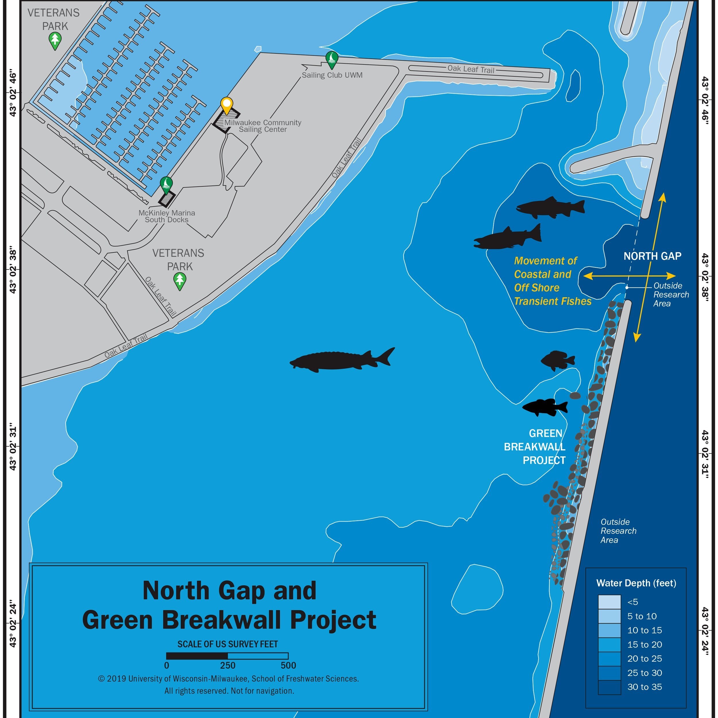
Jeff designed visualizations like this one that show how to modify a breakwall underwater to promote fish habitat when harbor infrastructure is up for maintenance.
Now Jeff is continuing and expanding the harbor mapping work started in the Milwaukee Estuary by another SFS graduate, Brennan Dow, who now works for the Wisconsin Department of Natural Resources helping to manage the resource he studied while at the school. What started in Milwaukee has blossomed to encompass harbor surveys of Port Washington, Sheboygan, Two Rivers, and Manitowoc. Jeff takes a boat to each harbor, takes depth soundings, and deploys side-scan sonar to capture a sonic image of the bottom. Later in a computer program, he stitches together and interprets the imagery. Jeff will then flag any areas of interest and return to investigate those later with an ROV or scuba dive. The maps created from the field surveys are expected to be finalized in late 2021 and will be used to inform local urban planners, harbormasters, and the public. They provide an important baseline about current fish habitat—the first step to enhance or better connect what’s already there. Jeff hopes a future phase will expand the work to explore the harbors of Racine, Kenosha, Algoma, and Kewaunee. “We’re hoping to keep on going down the coast,” he says. “A lot of communities don’t realize we’re out here. We’re here for you.”

Jeff designed visualizations like this one that show how to modify a breakwall underwater to promote fish habitat when harbor infrastructure is up for maintenance.
A harbor map illustrated by Kim Beckmann; click to learn more about the Milwaukee Estuary harbor habitat hotspot maps.

Jeff Houghton on a Lake Michigan dive.